
Page 77 - NZDPM 33/2017
P. 77
76 Strus Iu., Bokotey A., Dzubenko N.
data is available as rasters with spatial resolution of 1 arc-second per pixel, or
approximately 30 meters per pixel at the equator. This data represents forest loss in the
period between 2001 and 2014 in comparison to the global forest coverage (with the same
spatial parameters) in the year 2000.
The GFW data represents forest loss regardless of causes of a loss. For instance, it
shows forest loss caused by logging, fires and by other reasons combined. In our study, we
would like to focus on the forest loss caused by logging. Unfortunately, there is no way to
separate different causes of a loss in the GFW data, but in the case of the Rivne region
forest fires are not the main reason of the forest cover loss. Based on our experience and on
the unpublished data we can estimate the scale of loss due to fires as less than 20%.
Another 80% of the forest loss in the region is caused by logging.
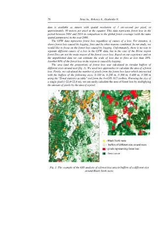
The area (and the proportion) of forest loss was calculated in circular buffers of
different sizes around nest (fig. 1). We used two approaches to calculate the area of a forest
loss. Firstly, we calculated the number of pixels from the forest loss layer which intersected
with the buffers of the following sizes: 0-100 m, 0-200 m, 0-300 m, 0-400 m, 0-500 m
using the "Zonal statistics as table" tool from the ArcGIS 10.5 toolbox. Knowing the size of
a single pixel (~22,4×22,4 m), we can easily calculate the area of forest loss by multiplying
the amount of pixels by the area of a pixel.
Fig. 1. The example of the GIS analysis of a forest loss area in buffers of a different size
around Black Stork nests.